
Availability and use of biodiversity data
Last updated: 2026
Latest data available: 2026
Introduction
This indicator presents trends in the use of biodiversity records, download events, and total number of users. Data for this indicator is provided by the National Biodiversity Network (NBN) Atlas.
Good policy making and evaluation is based on evidence. Millions of biological observations (records) have been recorded in the UK over the past century by a wide variety of organisations and individuals. This indicator provides an evaluation of the use and spatial resolution of records in the National Biodiversity Network (NBN) Atlas over time, as a proxy for the evidence available to underpin conservation decision making.
Data for this indicator can be found in the published datafile.
Type of indicator
Response indicator
Type of official statistics
Official statistic
Assessment of change
The data series used for this indicator does not allow long-term assessment of change in the measures included.
| Measure | Assessment | Time period | Result |
|---|---|---|---|
| Number of records downloaded | Short term | 2020 to 2025 | Improving |
| Number of download events | Short term | 2020 to 2025 | Improving |
| Number of NBN Atlas users | Short term | 2020 to 2025 | Improving |
Notes on the indicator assessment
- Long- and short-term assessments are based on a 3% rule of thumb (see Assessing Indicators).
- The full data series for this indicator starts in April 2017 and finishes in March 2026. Assessments are based on the last 5 years which have data for all four quarters (2020 - 2025).
- Assessments are based on calculating the number of records downloaded, download events, and number of users in a start year, and comparing that with the end year.
Key results
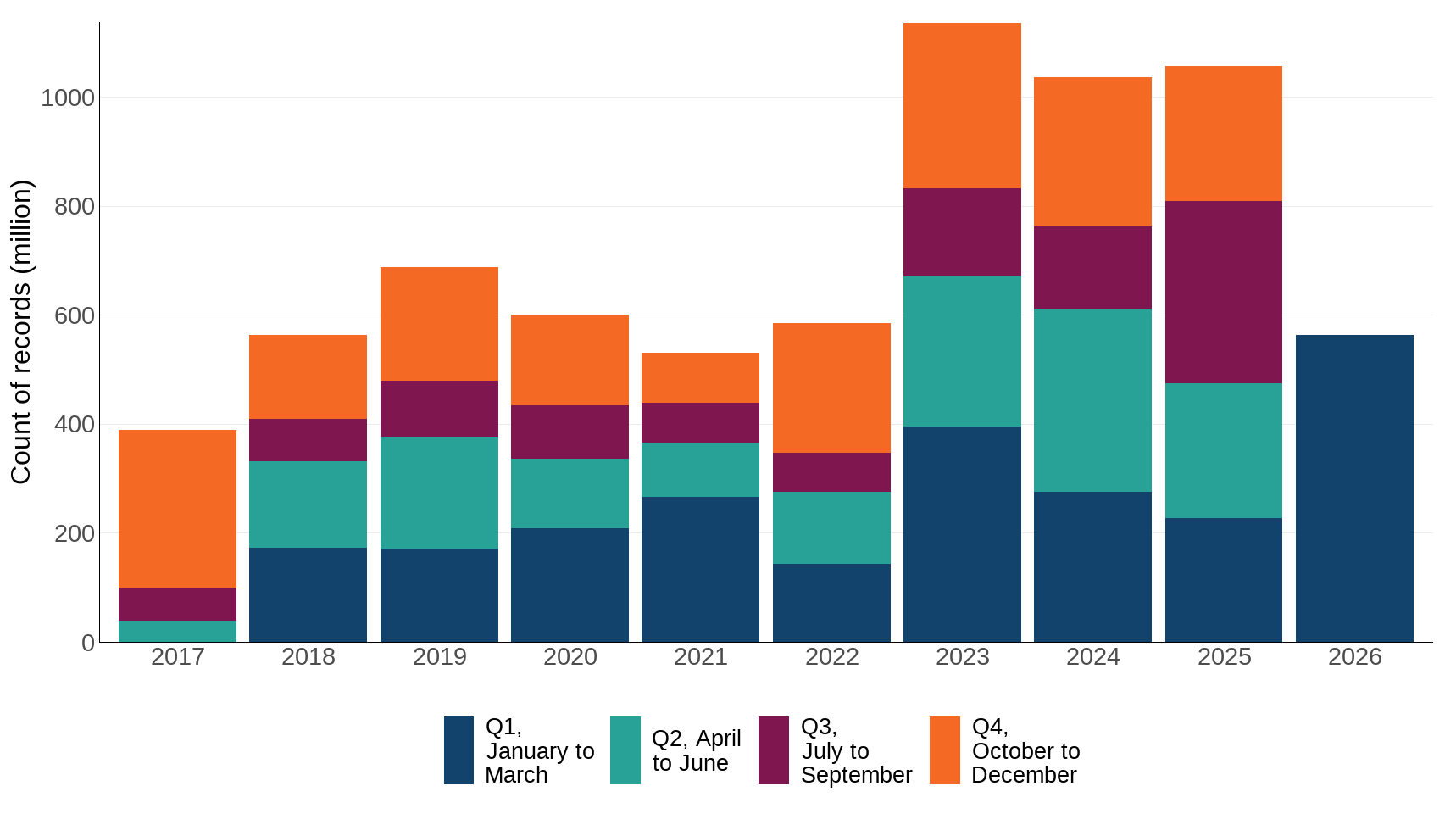
In 2020 600 million records were downloaded from the NBN Atlas; this increased by 77% to over 1.06 billion records in 2025 (Figure 1).
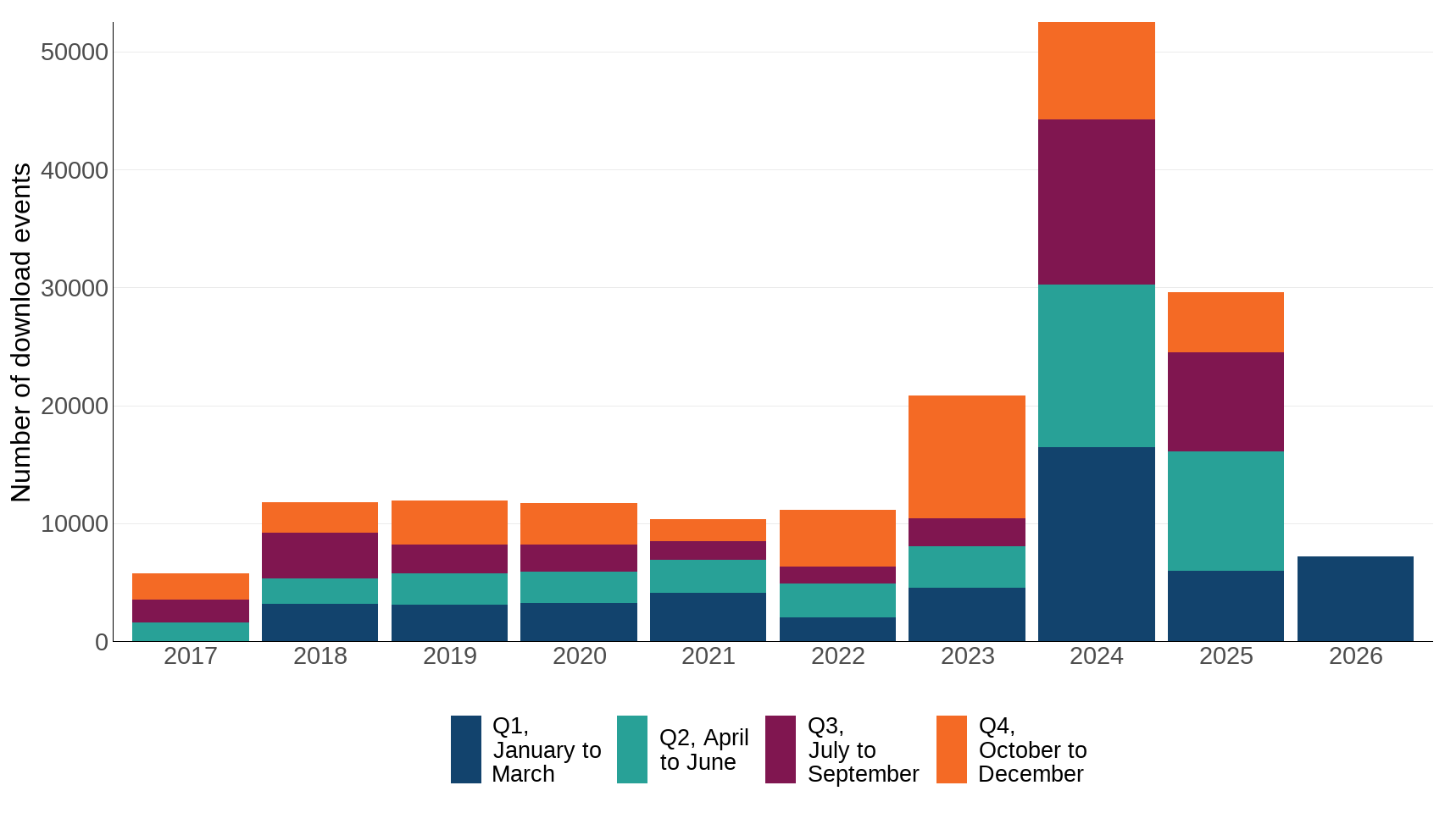
In 2020 the number of download events was 11,718. This increased 153% to 29,595 download events in 2025 (Figure 2).
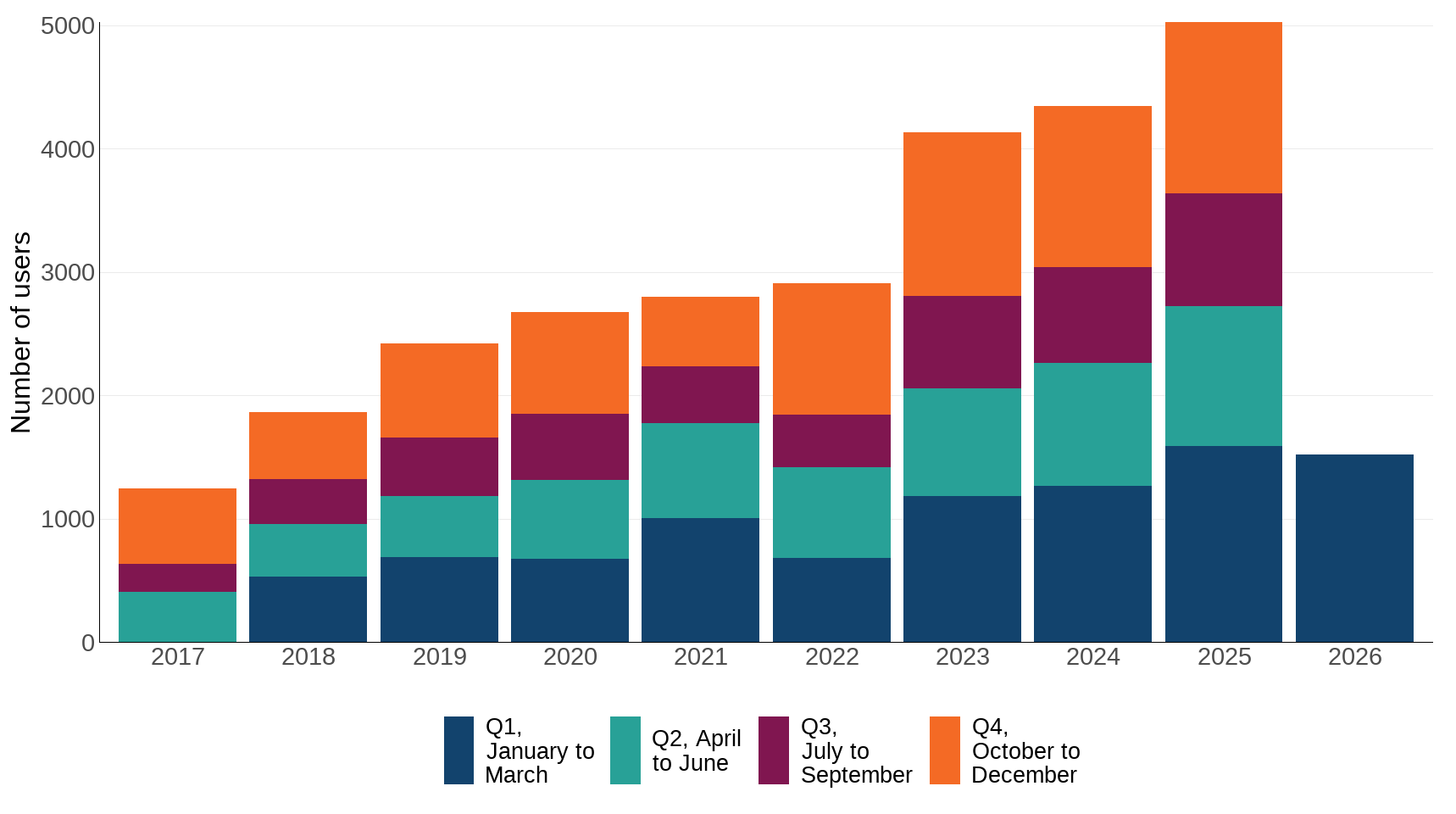
In 2020 the number of users downloading records was 2,673. This increased 88% to 5,025 in 2025 (Figure 3).
Figure 1: Number of records downloaded per year, 2017 to 2026
Source: National Biodiversity Network Trust
Notes about Figure 1
- The data series starts in April 2017; data from the first quarter of 2017 is not available for reporting.
- Figures here aggregate the number of records, which are associated with a month, into year quarters and then stack these into calendar years.
- Individual records may be downloaded on multiple occasions, and therefore the number of records downloaded per quarter are not unique records.
- In early 2026, 270 million records were downloaded by a single user, leading to a higher Q1 total for that year.
- In 2026, the NBN Atlas limits individual download events to 500,000 records. This maximum is subject to review, and users can make more than one download.
Figure 2: Number of download events per year, 2017 to 2026
Source: National Biodiversity Network Trust
Notes about Figure 2
- The data series starts in April 2017; data from the first quarter of 2017 is not available for reporting.
- The high number of records downloaded in 2024 may be due to new biodiversity legislation enacted at this time; however, this cannot be verified.
Figure 3: Number of users downloading records, 2017 to 2026
Source: National Biodiversity Network Trust
Notes about Figure 3
- The data series starts in April 2017; data from the first quarter of 2017 is not available for reporting.
- Individual users may download records on more than one occasion, so the users downloading records may be duplicated.
Further detail
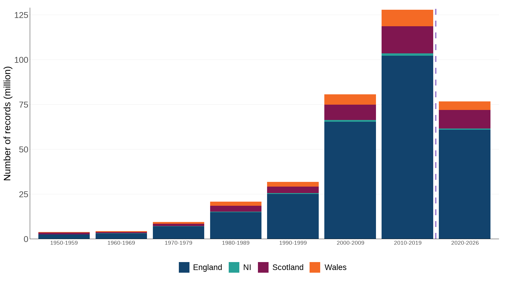
Millions of biological observations (records) have been recorded in the UK over the past century by a wide variety of organisations and individuals (Figure 4). Most of these records are documented by volunteers who organise themselves through many national and local societies and recording schemes. The UK and devolved governments (through their conservation and environmental bodies), local government and non-government wildlife-related organisations all collect and use biodiversity data. Information is held by many different organisations, and the individuals who collect it use a variety of formats, from computer databases to handwritten record cards. This means that although a huge amount of information exists, it is not always easy to access.
Figure 4: Records within the National Biodiversity Network associated with a decade, 1950s to 2026
Source: National Biodiversity Network Trust
Notes about Figure 4
- Data for the period 2020 to 2026 is included as a partial decade in this figure, indicated by the vertical purple dashed line.
- Dates in this figure refer to the date of the record, not when the record was added to the NBN.
One of the principal means of collation and interpretation of this data is the network of local records centres and the Biological Records Centre (BRC), which collates and interprets data from many national recording schemes. The BRC update over 60 data resources on the NBN Atlas, often every month. These are datasets from recording schemes and projects that use iRecord for record management and verification. The majority of the records shared are verified but some schemes and projects also share unverified records, which are clearly flagged as such within the NBN Atlas. BRC also supplies unverified data to the NBN Atlas for some species groups that are not currently covered by a national recording scheme.
Over recent decades, biodiversity records have been accumulating increasingly rapidly (Figure 4). During the period between the beginning of March and the end of April 2016, a large number of new and updated datasets were loaded on the NBN Gateway (around 210), including a new UK Butterfly Monitoring Scheme (UKBMS) dataset which added 5.7 million records. In addition, the update to the Butterfly Conservation’s National Moth Recording Scheme dataset added around 20 million records on the NBN Gateway.
A very large number of records were added to the NBN in April 2017 as a result of the changeover from the NBN Gateway to the NBN Atlas. Some of the large increase in the number of records is a result of the British Trust for Ornithology (BTO) adding 10 new datasets which accounted for nearly 156 million records in the Atlas. Approximately 55.8 million of the 95.5 million records that were on the Gateway were transferred to the Atlas. The remaining records were not transferred for a variety of reasons, such as data providers not taking the opportunity to update the datasets and/or requiring permission from the data owners. Figure 4 presents the date associated with those records.
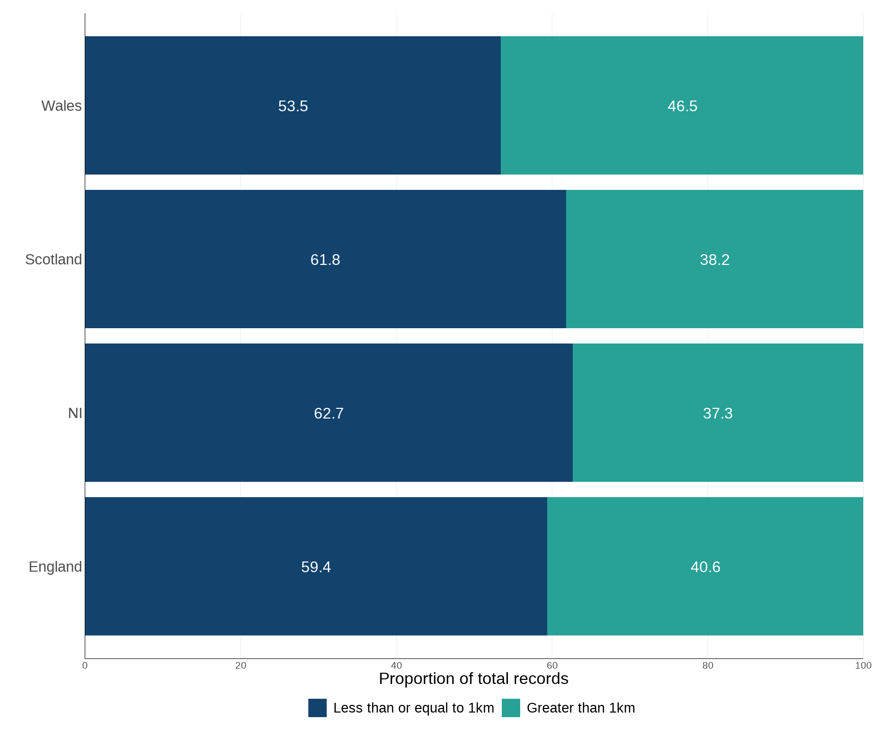
Records at a smaller geographical scale or resolution provide a more accurate location for where species were recorded, and help to provide more detailed information, for example, in infrastructure or house-building planning casework. Figure 5 shows a snapshot of the proportion of records at different spatial resolutions since April 2017. Over time the resolution of records has improved; Table 1 shows that there are many fewer records in the NBN Atlas at a resolution of greater than or equal to 10km2 than those less than 1km2.
Figure 5: Proportion of biodiversity records by spatial resolution, 2017 to 2026
Source: National Biodiversity Network Trust
Notes about Figure 5
- This data is aggregated since April 2017 to show the availability of data at different spatial scales.
- For display purposes all data above 1km2 resolution have been combined. The full data is in Table 1.
Table 1: NBN records by spatial resolution
| Country | <1 km | 1-10 km | >10 km |
|---|---|---|---|
| UK | 213,682,422 | 146,848,377 | 356,251 |
| England | 167,949,715 | 114,529,923 | 275,043 |
| Scotland | 27,392,514 | 16,838,583 | 60,388 |
| Wales | 14,225,297 | 12,366,847 | 7,622 |
| NI | 2,516,720 | 1,487,353 | 11,507 |
Notes about Table 1
- NI: Northern Ireland.
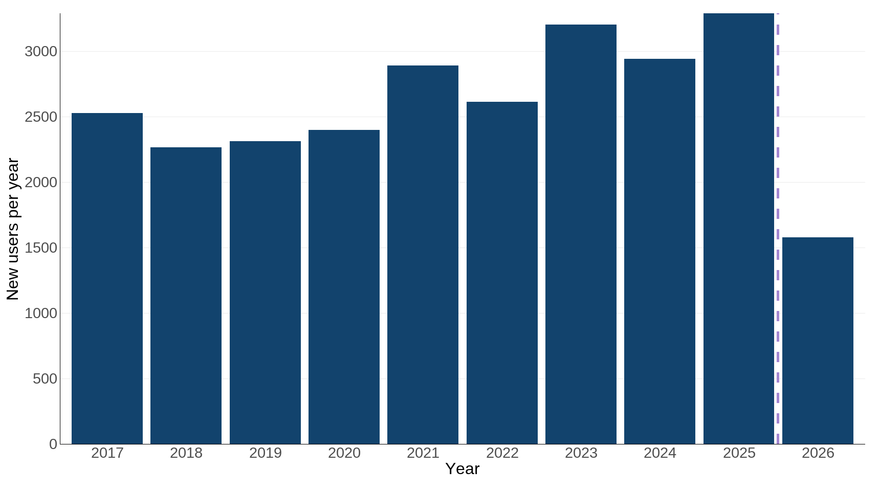
Figure 6 and Table 2 show the number of users registered with the NBN Trust to be able to download records and the sectors they have identified in their registration. A wide variety of affiliations are registered, showing the range of uses to which biological records can be put.
Figure 6: Number of new NBN Atlas users by year, 2017 to 2026
Source: National Biodiversity Network Trust
Notes about Figure 6
- Data for 2026 is included as a partial decade in this figure, indicated by the vertical purple dashed line.
- Users need to register with the NBN Atlas if they wish to download data.
- Individuals may register for a particular download event, or may make multiple downloads within a year, or may be registered for multiple years, depending on what use they wish to make of NBN data.
Table 2: NBN Atlas user affiliations since 2017
| Affiliation | Count |
|---|---|
| Academia and research | 7,943 |
| College and university student | 4,301 |
| Ecologist | 2,332 |
| Not supplied | 2,308 |
| Personal interest | 2,270 |
| Environmental consultant | 1,480 |
| Recorder and recording scheme | 1,273 |
| Local and national government | 983 |
| Teaching and education | 906 |
| NGO staff | 805 |
| Agriculture, forestry and fishing | 567 |
| Construction, utilities and technology | 515 |
| Artist, journalist, photographer | 135 |
| LERC staff | 118 |
| Museums, botanical gardens and aquaria | 72 |
Source: National Biodiversity Network Trust
Notes about Table 2
- These categories are defined by users when they register to download records from the NBN Atlas.
- These data are a snapshot of user affiliations of the NBN Atlas since 2017.
- NGO: Non-Governmental Organisation; LERC: Local Environmental Records Centre.
FAIR data principles
All data accepted into and maintained within the NBN Atlas are aligned with the FAIR data principles, which aim to ensure that data is Findable, Accessible, Interoperable and Reusable. As outlined by Wilkinson et al. 2016, the FAIR principles aim to increase the ability of machines to find, access and use data, supporting knowledge discovery and innovation. For more details on the FAIR principles, please see the Technical Annex.
- All datasets submitted to the NBN Atlas must include suitable metadata. Metadata is information which describes other data, including the broad context, and specific information such as who collected the record, the species it relates to, when it was collected, and how it can be used. It is intended to enable data to be easily discovered, interpreted and reused by others. NBN follows the Darwin Core data standard, which aims to facilitate sharing of biological records by standardising identifiers, labels and definitions.
- NBN Atlas data is free to view and download, and accessibility of the data is ensured by the data standards and metadata outlined above. However, this can make quantifying who is accessing the data complex. In this indicator we therefore include the self-reported affiliations of users, to give an outline of who is accessing the data - see Table 1.
- To ensure interoperability, the NBN Atlas uses the Natural History Museum's UK Species Inventory which uses Taxon Version Keys to standardise reference and common names for more than 70,000 UK species covering animals, plants, fungi and single celled organisms.
- All records on the Atlas are shared under a Creative Commons licence or an Open Government Licence; and approximately 80% of records are free to use for any non‑commercial purpose.
Together, these standards enable data to be found, analysed and researched as widely as possible, and ensure accessibility.
Relevance
Good policy making and evaluation is based on evidence. Evidence also helps to engage the public, natural resource managers and business to actively address biodiversity loss. There are therefore a range of geographic scales of decision making (from local to national) and audiences (public sector, industry, public, research, etc.) that have an interest in the availability of biodiversity data.
International and domestic reporting
The UK and England Biodiversity Indicators are used for a variety of reporting and other purposes. This includes international reporting, such as the UK's National Reports to the Convention on Biological Diversity (CBD) on progress towards the goals and targets of the Kunming-Montreal Global Biodiversity Framework; this is the Headline Indicator for Target 21. They are also used to track the state of biodiversity domestically, such as in England’s Environmental Indicator Framework.
Web links for further information
- National Biodiversity Network (homepage)
- National Biodiversity Network (history)
- National Biodiversity Network Atlas
- Biological Records Centre
- Biological Records Centre recording and monitoring schemes
- Wilkinson, M., Dumontier, M., Aalbersberg, I. et al. The FAIR Guiding Principles for scientific data management and stewardship. Sci Data 3, 160018 (2016)
Acknowledgements
Thank you to the many people who have contributed by providing data and to the many colleagues who have helped produce this indicator, particularly Will Millard and Keith Raven at the National Biodiversity Network Trust.
Technical annex
The NBN Atlas is a free online tool that provides a platform to engage, educate and inform people about the natural world. It enables the combination of multiple sources of information about UK species and habitats, and provides the ability to interrogate, combine and analyse these data in a single location. Individual records, for example for plants, mammals, birds and invertebrates, are stored on the NBN Atlas. Records can be quickly and easily accessed and displayed on a map of the UK in a number of different ways to aid understanding of the distribution of particular species in the UK.
This biological information is vital if the distribution and abundance of species and habitats is to be understood. Without it, making informed decisions on how to protect the UK’s wildlife is much more difficult.
The NBN website works to set standards for data exchange and data accuracy, and captures wildlife data in a standard electronic form, allowing the integration of data from different sources, and use of the internet to enable data to be used in different ways by as many people as possible. The history of the development of the NBN Gateway and Atlas, and a detailed timeline are available from the NBN website.
Key milestones to note in the context of this indicator:
- The development of a prototype NBN Gateway in 2001.
- The redevelopment and relaunch of the Gateway in November 2013.
- The switch to the NBN Atlas in April 2017.
Registered users can request enhanced access to records of sensitive species from data providers through the NBN Atlas. If granted, the user can access higher resolution data just like under the previous NBN Gateway system. This gives data providers control over who can use their data for particular purposes. Where requests are made to access protected species records through the NBN Atlas, this can be given, but the location details are generalised in order to protect the location of the protected species. Enhanced access through the NBN Atlas is not available for all records, therefore users may need to contact data providers for this additional information. Government and its arms-length bodies have, over recent years, been moving towards open data, and the development of the NBN Atlas fits with that agenda.
The FAIR principles are described in detail by the GO FAIR initiative. Data should be:
Findable
- F1. (Meta)data are assigned a globally unique and persistent identifier.
- F2. Data are described with rich metadata (defined by R1 below).
- F3. Metadata clearly and explicitly include the identifier of the data they describe.
- F4. (Meta)data are registered or indexed in a searchable resource.
Accessible
- A1. (Meta)data are retrievable by their identifier using a standardised communications protocol.
- A1.1 The protocol is open, free, and universally implementable.
- A1.2 The protocol allows for an authentication and authorisation procedure, where necessary.
- A2. Metadata are accessible, even when the data are no longer available.
Interoperable
- I1. (Meta)data use a formal, accessible, shared, and broadly applicable language for knowledge representation.
- I2. (Meta)data use vocabularies that follow FAIR principles.
- I3. (Meta)data include qualified references to other (meta)data.
Reusable
- R1. (Meta)data are richly described with a plurality of accurate and relevant attributes.
- R1.1. (Meta)data are released with a clear and accessible data usage license.
- R1.2. (Meta)data are associated with detailed provenance.
- R1.3. (Meta)data meet domain-relevant community standards.
Caveats and limitations
This indicator is focused on the availability of data collated by the National Biodiversity Network as a proxy for data being used for conservation decision making. Evaluating actual data use within decision making is challenging and not reported here.
Development plan
We are keen to hear from our users about this indicator, as well as our published development plan, please email us.
Categories:
Published: